Safer School Streets scheme made permanent
Frome’s Safer School Streets scheme is here to stay, following the end of an 18-month trial period. Frome’s scheme was spearheaded by Frome Town Council, via funding from Active Travel England and in partnership with Somerset Council and active travel charity Walk Wheel Cycle Trust (formerly Sustrans).
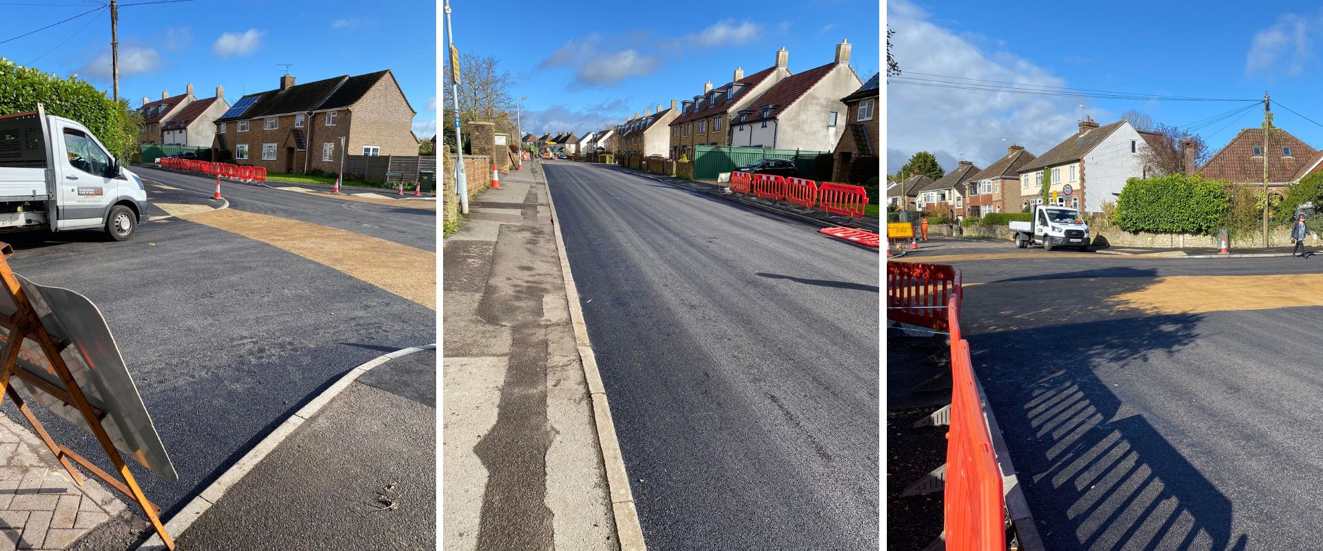
Following a review of quantitative data collected during the trial, and the results of FTC’s town-wide perception survey, the Traffic Regulation Order has been made permanent by Somerset Council, as the Highways Authority. This means that the timed road closures, 20mph limit and traffic-calming measures in the areas around Oakfield, Trinity and Critchill schools, and on Park Road near Avanti Park School will remain on a permanent basis.
You can download some of the data collected during the trial and via a town-wide survey below.
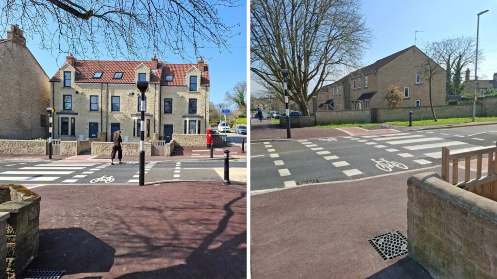
A crossing for The Butts
4th April 2025
The new crossing is complete. Thank you to residents for their patience during the works. If you have any questions or comments, please contact engage@frometowncouncil.gov.uk.
The Safer School Streets trial began on Monday 22nd April
Frome Town Council is working with Somerset Council and Sustrans on the Frome pilot of a Safer School Streets project. As of Monday 22nd April 2024, the following road closures will operate:
Junction of Broadway and Oakfield Road, until junction of Oakfield Road/Nunney Road and Critch Hill: closed 8.10am till 9am and 2.45pm to 3.30pm, Monday to Friday in term time. Whitemill Lane is also closed at these times.
Park Road: closed 8.25am to 8.55am and 3pm to 3.30pm, Monday to Friday in term time
The ETRO (Experimental Traffic Regulation Order) for the Safer School Streets trial details the following, limited exemptions to the road closures:
- blue badge holders
- parents/guardians of pupils with EHC plans
- school staff
- access to residential properties within the restricted zone
- healthcare workers
- users of Harry’s Hydrotherapy Pool
- school and public transport
- emergency services
- postal services
- utilities
- highway maintenance
- street cleansing and waste collection
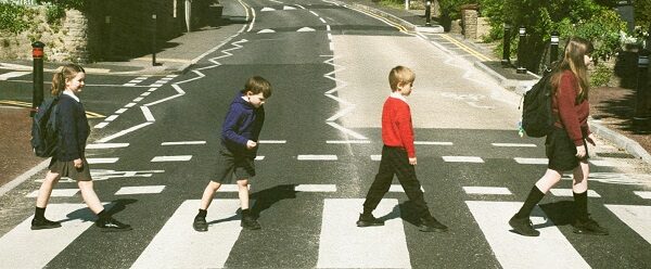
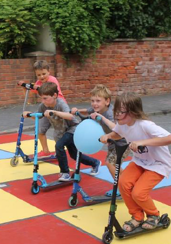
The first Safer School Street zone was launched in Italy in 1989, with the first UK scheme in Edinburgh in 2005. The aim is to improve safety for everyone. by encouraging active modes of travel while reducing traffic volume, traffic speed and improving air quality. Active journeys to school are proven to have a positive impact on children’s physical and mental health.
Safer School Streets update
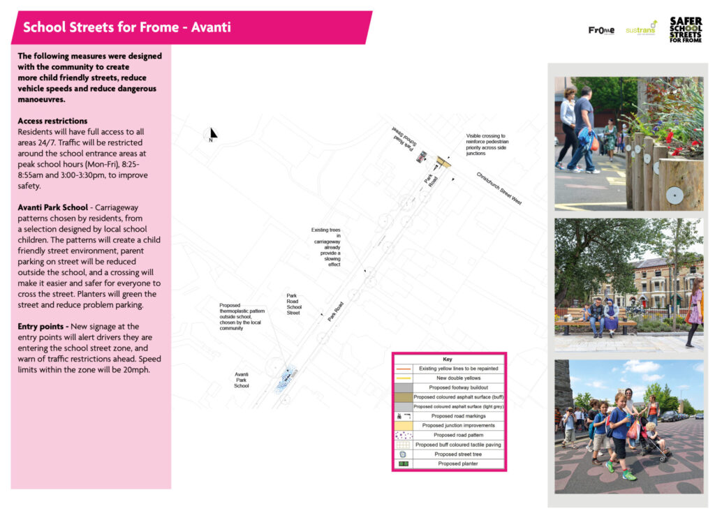
The plans for the road closures and new traffic-calming measures, such as pollinator-friendly planters on the roads and highway improvements designed to reduce speed and make crossing the road safer, can be viewed below. A new 20mph zone will operate across a wider area around the schools – see the map further down this page.
Road closures
Frome Town Council and the Safer School Streets contractor Northavon have worked with Somerset Highways to arrange the road closures necessary during the installation. The map below shows the areas with timed closures and extensions to the 20mph zone.
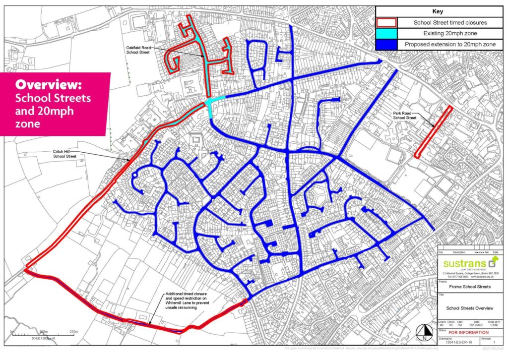
Download overview map of closures & 20mph zone.
The Frome Safer School Streets trial will run for a period of 18 months. For more details, read the information below or jump to our FAQs.
Keep up to date
Please join our newsletter mailing list to receive regular updates about the scheme.
What is a ‘Safer School Street’?
A Safer School Street is an area that limits vehicle access during school pickup and drop-off making it safer for people to walk or wheel to school. All residents who live in the Safer School Streets area will still be able to access their street without restriction as will buses, emergency services and people with disabilities. School staff will be able to access the car parks, to minimise cars parked on the street. All families heading to school will be asked to either walk or wheel, or where not possible, to park and stride a short distance.
The aims of the trial are to increase safety outside the school gates, reduce toxic air pollution, and increase active travel contributing to the wellbeing of children and their families.
Where are the Safer School Streets zones?
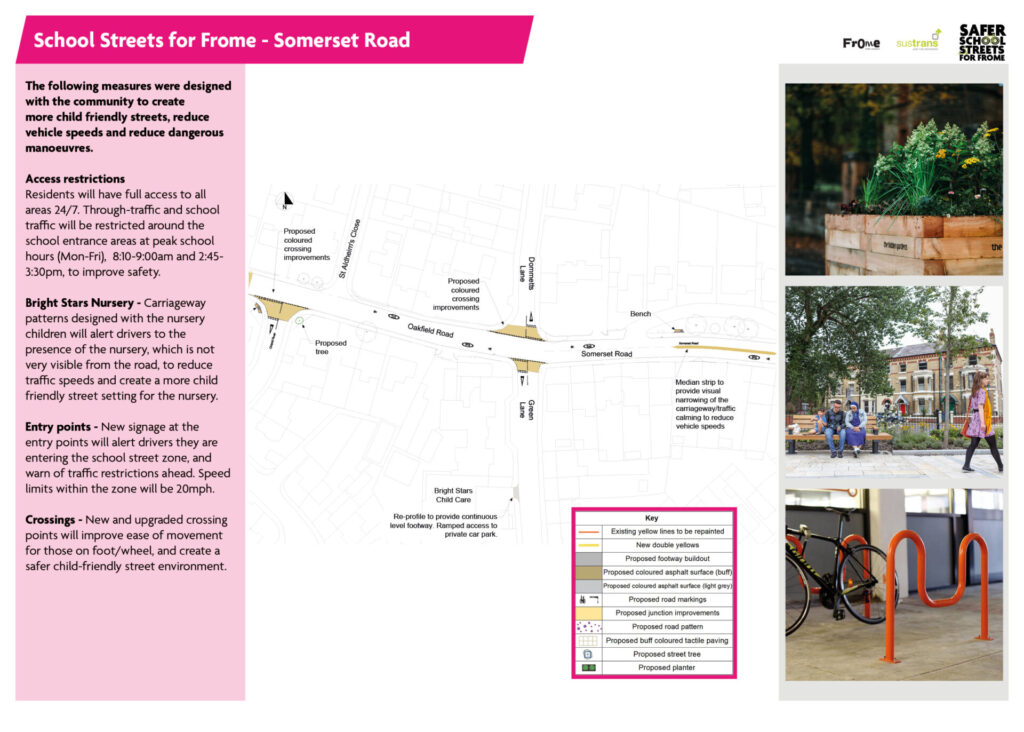
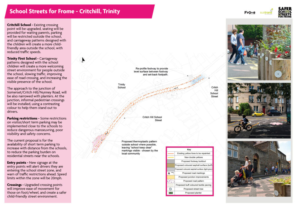
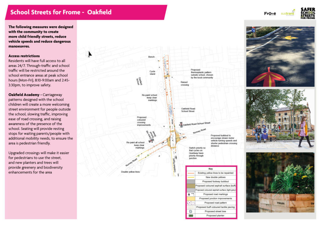
The identified Safer School Streets zone will serve four schools and over 1500 children – Oakfield Academy, Trinity First School, Critchill School, and Avanti Park. Sections of Oakfield Road and Nunney Road will have limited vehicle access at drop off and pick up times between Monday and Friday. A 20 mph limit will be introduced along all adjoining roads.
Download the Safer School Streets plans
How will it happen?
There are three stages to implementing Safer School Streets:
Stage 1 – Co-design A series of events to co-design the changes before we trial them. This phase is complete.
Stage 2 – Implementation Our contractor will install the thermoplastics, or ‘street carpets’, raised crossings and road markings and traffic calming planters, during late winter/Spring 2024. The Safer School Streets trial will begin in April 2024 and run for 18 months. We will collect feedback from schools, local residents, businesses and the wider community throughout the trial period via an online survey. It will also be available on paper in the town hall.
Stage 3 – Decision From summer/autumn 2025, we will review the trial and decide, with the community, whether the Safer School Street zone should be a permanent fixture. It is key that residents engage with the plans and share their local knowledge and feedback to deliver safer streets for our whole community
We’ve compiled an FAQ document about the project; if you don’t find the answer to your question, please feel free to contact us.
Background of the project
Safer School Streets consultation
In September and October 2021 Frome Town Council and Sustrans ran a series of seven community co-design events to inform the design of a School Streets scheme around Trinity, Critchill, Oakfield and Avanti schools and Bright Stars Nursery.
Frome Town Council ran a public consultation on the draft School Streets design from 4th April – 4th May 2022. This included an online survey via Commonplace, two drop-in sessions at Frome Town Hall and several outdoor sessions outside the schools throughout the month.
Past sessions
Autumn 2021
Between September and November 2021 seven co-design events were held in various locations and online providing an opportunity for members of the public to share their thoughts and participate in co-designing the Frome School Streets scheme.
Spring 2022
Between 4th April and 4th May the draft was available to review and comment on online and in person at Frome Town Hall. Drop-in sessions were also held at the Town Hall on 7th and 20th April and at the crossroads of Nunney Road and Oakfield Road on the 5th, 26th and 27th April.
January 2023
There were further opportunities to discuss the plans as a Quiet Way was added and as the designs changed subject to feedback.
Designs finalised based on Somerset Highway Authority’s safety audit and the final budget.
Contact us
If you have any questions about School Streets that aren’t answered on this page, please email us.